愛と欲望のジャイサルメール 『世界最大の地上絵の謎に挑んだ男』ラジウム発見記 Jaisalmer of love and desire: “Taking on the mystery of the world’s largest geoglyph”

There must be radium underground under the Snake Line❗️The world's first discovery 10 years after the discovery of the Jaisalmer Line, I...

Archaeological Research in Asia
Full length articleNew enigmatic geoglyphs in the Indian Thar Desert: The largest graphic realizations of mankind?
Abstract
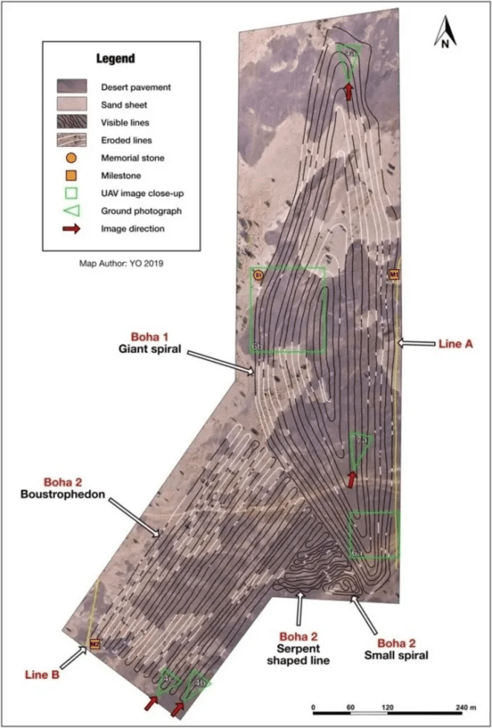
A meticulous survey of the Indian Thar Desert with Google Earth led us to identify eight sites in the Jaisalmer District, with clear geometrical lines that may resemble geoglyphs. The data collected in the field, together with images taken by a drone, revealed the exceptional character of the graphic patterns near the village of Boha. Two remarkable geometrical figures: a giant spiral adjacent to an atypical serpent shaped drawing, are connected with a cluster of sinuous lines. This triad extends over 20.8 ha and totals more than half of the 48 km of lines observed. Three memorial stones positioned at key points, give evidence that planimetric knowledge has been used to create this elaborate design. These artifacts allow us to envisage hypothetical modalities of edification. We collected indicators of antiquity suggesting that these lines may be at least 150 years old and possibly linked to the Hindu memorial stones surrounding them. The lack of visibility from the ground raises the question of their function and meaning. So far, these geoglyphs, the largest discovered worldwide and for the first time in the Indian subcontinent, are also unique as regards their enigmatic signs.

Introduction
Geoglyphs (from the Greek word gê, ‘earth’, and gluphein, ‘engraving’) are anthropogenic features built on the surface of the earth and considered by archaeologists as a type of rock art. These drawings, which are generally abstract and geometrical, more rarely represent anthropomorphic and biomorphic figures. This generic term is used to designate very diverse items with regard to their appearance, construction techniques and function. Their large dimensions, ranging from a few meters to several kilometers, constitute a common criterion that distinguishes them from other types of rock art, such as petroglyphs. According to each case, more specific terms have been utilized to designate them: earthworks, ground drawings, stone arrangements, mounds, geometric ditches, etc.
The oldest ones date back to the Late Upper Paleolithic (Mailland, 2012), while others, such as the Marree Man in Australia, were created during the contemporary era. Recent discoveries in Russia, Kazakhstan and India (this article), indicate that they are found in most regions of the globe. However, the majority are located in America and specifically in South America. They are most numerous in arid environments, where the conditions for their preservation and observation are optimal. Those found in the Nazca Desert (Peru) are by far the most famous and comprehensively studied (Aveni, 1990). Major discoveries have also been made in forest ecosystems in Brazil and Bolivia, where more than 450 earthworks are currently being investigated (Pärssinen et al., 2009; Erickson, 2010; Schaan et al., 2012; Virtanen and Saunaluoma, 2017; Watling et al., 2017).
Two construction techniques, which may be combined, have been generally attested. The most common one in desert environments is the extractive technique. It consists in removing the upper oxidized stone pavement, thereby exposing the bright sandy layer below. The second, known as additive technique, involves the gathering of debris, piled on the soil surface.
Seen from an aesthetic point of view, some geoglyphs, such as ground drawings, are special forms of artistic expression. In addition to this subjective quality, the function and meaning exposed by scholars is extremely diverse. The main interpretations suggest sites for rituals and ceremonies, places of collective memory and rites of passage, defensive structures, landmarks, and astronomical functions (Valenzuela and Clarkson, 2014).
Our study describes a cluster of geometric lines detected in the Thar Desert (Western Rajasthan) in 2014, using Google Earth. This ecosystem, also known as the Great Indian Sand Desert, covers approx. 285,000 km2 at the eastern end of the Sahara-Arabian arid belt. The iconographic and dimensional singularities of these geoglyphs are presented here for the first time, based on a meticulous cartographic reproduction of the lines, completed by data collected in the field. This set of graphic expressions, as unique anthropogenic signs, has very interesting cognitive implications.

つまりですね。
蛇の様な地上絵は、ラジウム鉱山の目印だったわけです。証拠はアメリカで同じ地上絵を見たからです。
で、愛と欲望はどうなったのかって?

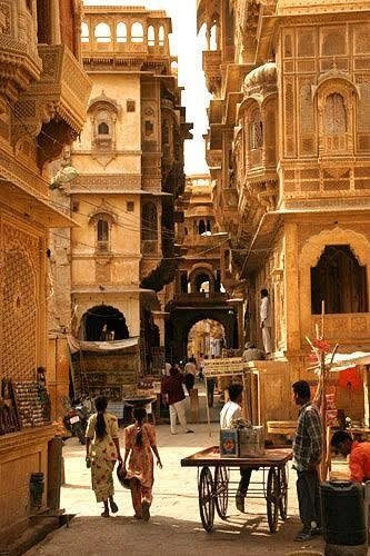
ウタイマーは、この広大な乾燥地の真ん中、通称"黄金の都市"ジャイサルメール周辺に、地上絵とおぼしき幾何学的な線が描かれた地帯がいくつかあるのを発見した。
2016年、無人航空機(UAV)を使って詳しく調べてみると、植林のために掘られた溝が認められたが、植物がないと思われる場所にも謎めいた線模様の一群があることもわかった
とくに、Bohaという村の近くにあるふたつの幾何学模様は非常に独特で、巨大ならせんやヘビのように見える図形が入り組んだ線でつながっている。
この図形を描いている線は、地面に刻まれた深さ10センチ、幅20~50センチの溝だ。これらは近くで見ると、なにを描いているのかさっぱりわからず、地上絵だとは気がつかない。
巨大な非対称のらせん(Boha1)は、長さ724メートル、幅201メートルの範囲に、全長12キロに及ぶ1本の線からできている。
この巨大な渦巻き模様の南西には、全長11キロの線で描かれたヘビのような図形(Boha2)がある。これは、ヘビのような姿、小さならせん、古代の犂耕体(左から右、右から左へと交互に行を進める書き方)の連なりを取り囲んでいる。
Boha付近では、その他の小さな地上絵も見つかっており(Boha3と名づけられた曲がりくねったライン)、今日、見ることができるラインの総延長は48キロメートルにもなる。かつては80キメートルに及んでいたのではないかと推定されている。
地上絵はいったい何をあらわしているのか?
この地上絵がなにを表わしているのか、誰が描いたのかについてはまだよくわかっていないが、これはそれほど古いものではなく、むしろ150年ほど前くらいの比較的新しい時代に描かれたものではないかと研究者は考えている。
付近で、ヒンドゥー教の記念碑が見つかっていて、同時代のものではないかとされる。
誰が描いたのかがはっきりしないままでは、この巨大地上絵の用途や意味を推測することは難しいが、それでも研究者たちにはいくつかの説をあげている。
土地がフラットであるため、この地上絵全体を俯瞰するには上空300メートル以上の高度が必要だ。だから、これらは地上から見る芸術的表現を意図したものではなく、むしろ未知の文化的行為として、作られたのではないかという。
答えは「ナスカ地上絵の謎 100年ぶりに解明」にあります。
で、愛と欲望はどうなったかって?
うふっ
それはわたしの問題なので、
ごきげんよう!
みなさん、ありがとう。この記事は「ナスカ地上絵の謎100年ぶりに解明」の証明方法の2つ目の補強証明です。単独では発表できません。インド政府が招請してくれない
アルデビッラ❣️
いいなと思ったら応援しよう!

