
北海道の廃線跡探訪 第106回 士幌線(5/7)電力所前~糠平間

1.ごあいさつ
ご訪問ありがとうございます。
北海道の廃線跡探訪 第106回 士幌線その5 電力所前~糠平間です。
この区間は糠平ダム建設による線路切り替えで、旧線と新線の両方の遺構が見られます。
旧線は国道の下方ですが、新線ははるか上方になっているので、接近困難なところもあります。橋の名称も、旧線と新線、橋梁と陸橋で似たようなものが多くて、ちょっと混乱してしまいます。
なお、これからの投稿予定路線などは、初回記事にありますので、そちらをご覧ください。
2.電力所前~糠平 その1

士幌線の新線は、電力所前仮乗降場からも25‰の急勾配で高さを稼ぎ、やがて糠平第1陸橋、つづいて屏風岩陸橋となる。


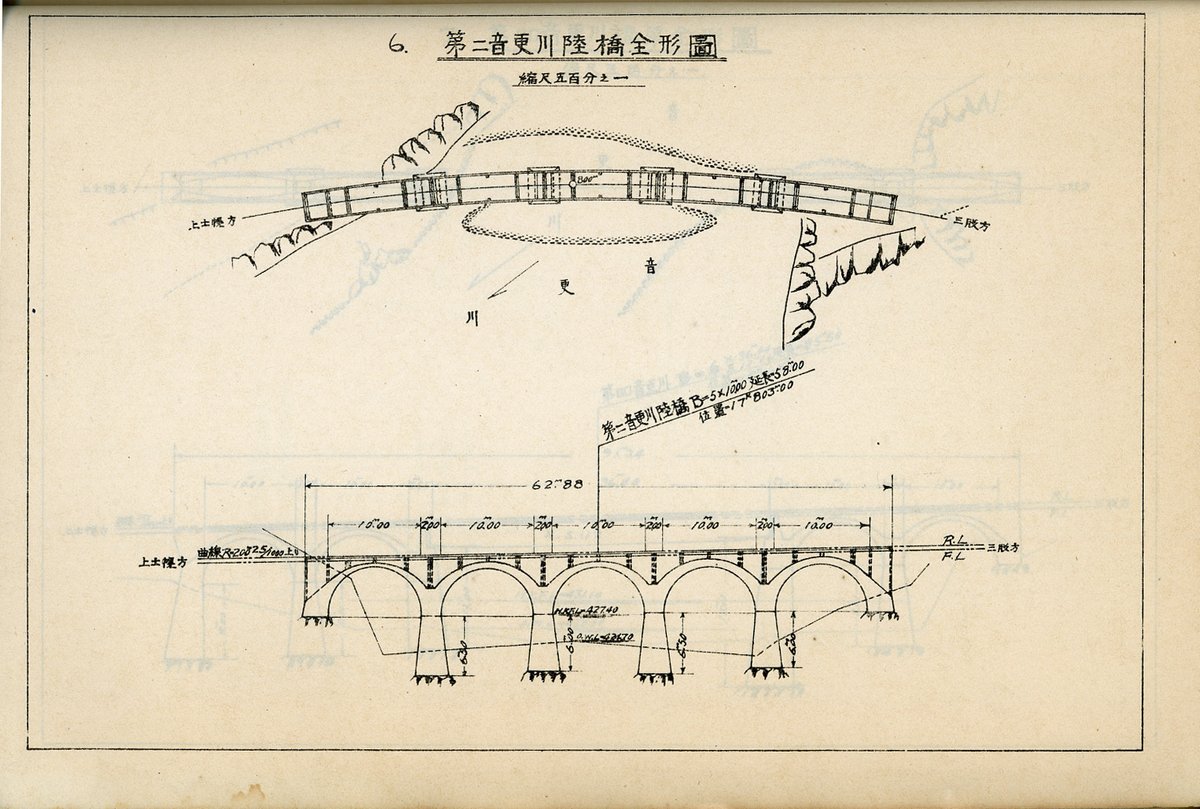
国道の鱒見トンネル入口附近から旧線の第2音更川陸橋が見える。
なお、その手前にあった旧線の第1音更川陸橋は、道路の拡幅のためか失われている。

1937(昭和12年)7月鉄道省北海道建設事務所『音更線混凝土拱橋工事概要』より
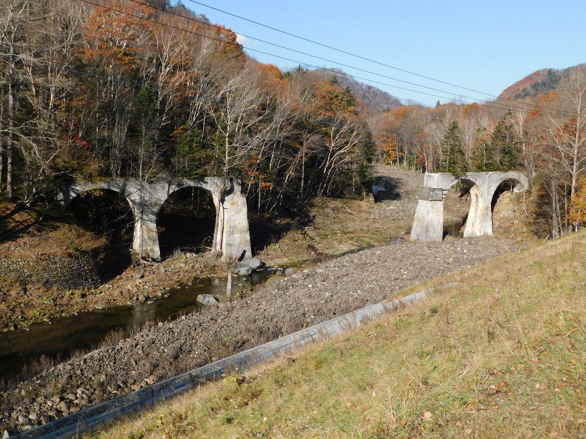
トンネル入口から分かれる旧道を行くと、上方には新線の糠平第2陸橋・スノーシェッド・下の沢陸橋が連続しているのも確認できる。
※タイトル写真は国道(鱒見トンネル糠平方)から見た新線、糠平第2陸橋~スノーシェッド~下の沢陸橋。下には旧線第4音更川橋梁も見える(2013年2月撮影)。

1937(昭和12年)7月鉄道省北海道建設事務所『音更線混凝土拱橋工事概要』より


下の沢陸橋を過ぎると、すぐ第1糠平トンネル、第2・3糠平トンネルが連続していた。さらに第2・3と第4の間には中の沢陸橋があるが、いずれも接近困難となる。

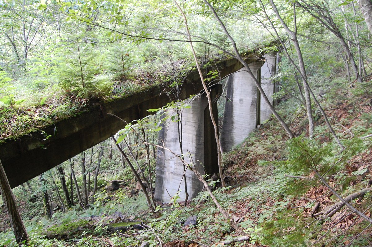
国道の鱒見トンネルを抜けると左下手に、ガーダーが撤去されアーチ部分だけとなった旧線の第4音更川橋梁がある。


1937(昭和12年)7月鉄道省北海道建設事務所『音更線混凝土拱橋工事概要』より
3.電力所前~糠平 その2

士幌線は糠平ダム堤体建設予定地を通っていたので、仮線を設けていた。仮線はダム堤体の手前で急カーブし、トンネルを抜け、まだ湛水前のダム湖(糠平湖)にあった糠平へ達していた。

1956年7月電源開発(株)発行『糠平ダム』より
雑誌連載取材時に参照したHPには、現存しているとあったが、当時は見つけられなかった。
ダム工事中の写真から推定して探ってみると、旧国道から行くしかなさそうだったので、現在車両通行止めとなっている国道を歩いてみた。
道路からはかなり下方になるが、幸いなことに斜面はそれほどきつくなく、ヤブでもなかった。樹木につかまりながら下まで降りると、路盤跡すらわからない。崖崩れでもあって埋まったかと半ばあきらめたとき、樹林の奥にそれらしきものが見えた。
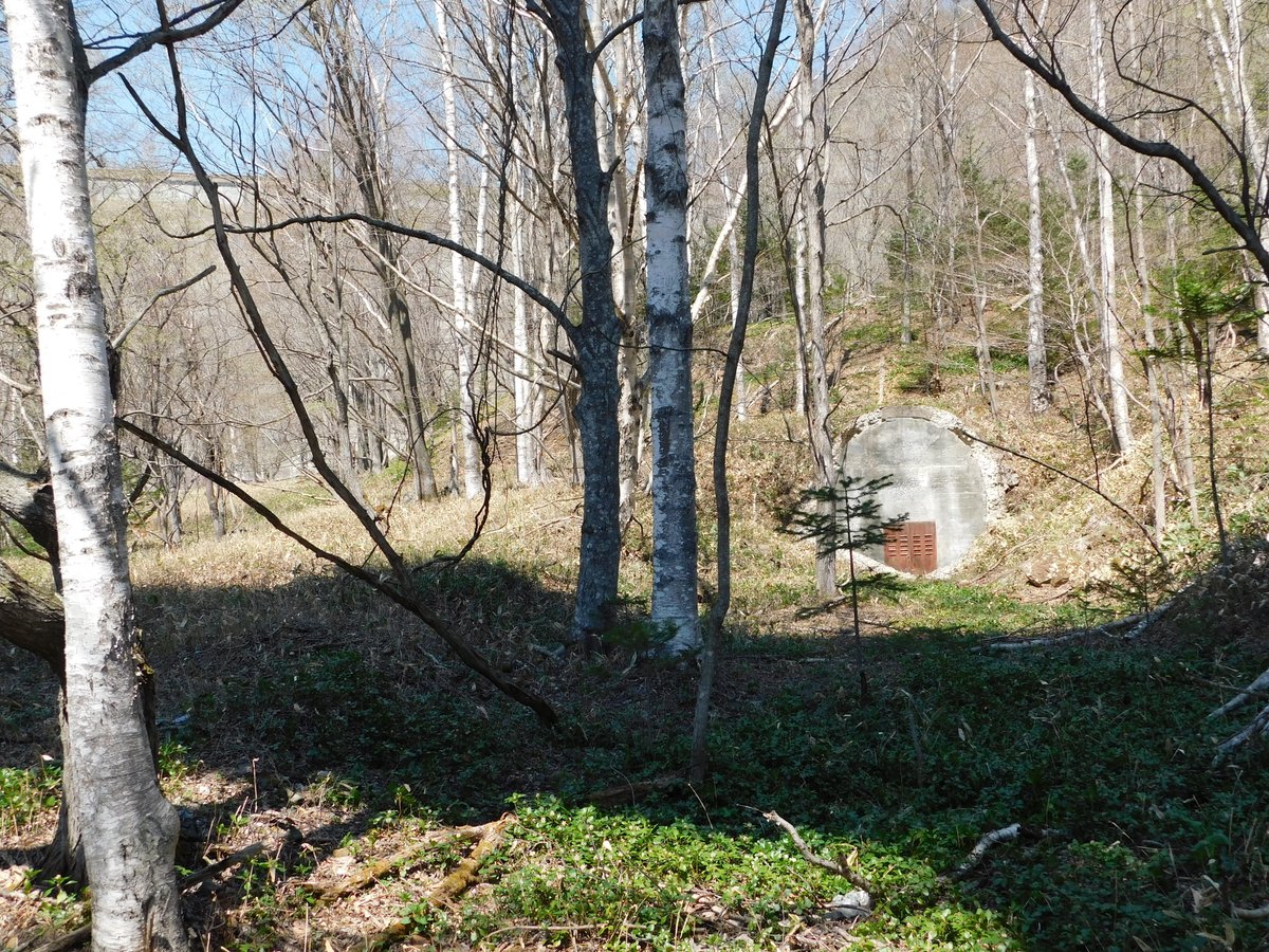
切り通しのようになったところを近づくと、確かに仮線トンネルらしい。なぜか扉が少し開いていたが、内部は当然ながら密閉されていた。それなら扉はいらないと思うが、倉庫にでも転用するつもりだったのだろうか。

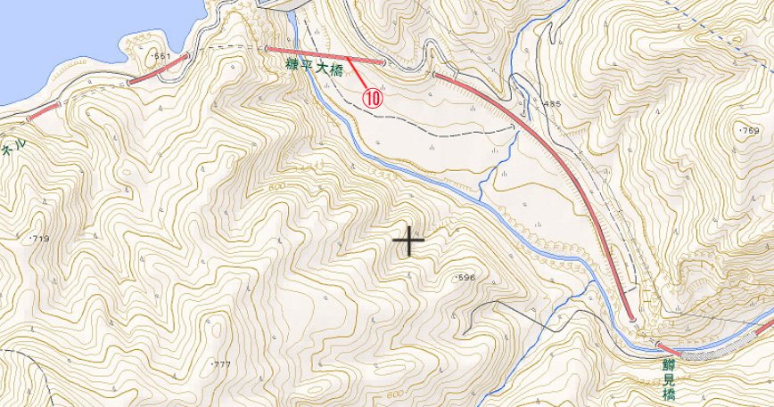
振り返ると、国道の糠平大橋が見える。これなら、橋上から見えるのではないかと思ったら、案の定、歩道からは見えた(車道からは見えない)。な~んだとちょっとガッカリした。

2024年5月撮影
帰りは路盤跡らしきところから、林道に出た。
帰宅して確認すると、どうやら旧線跡らしい。国道の築堤が見えたので、そこから直登して戻る。

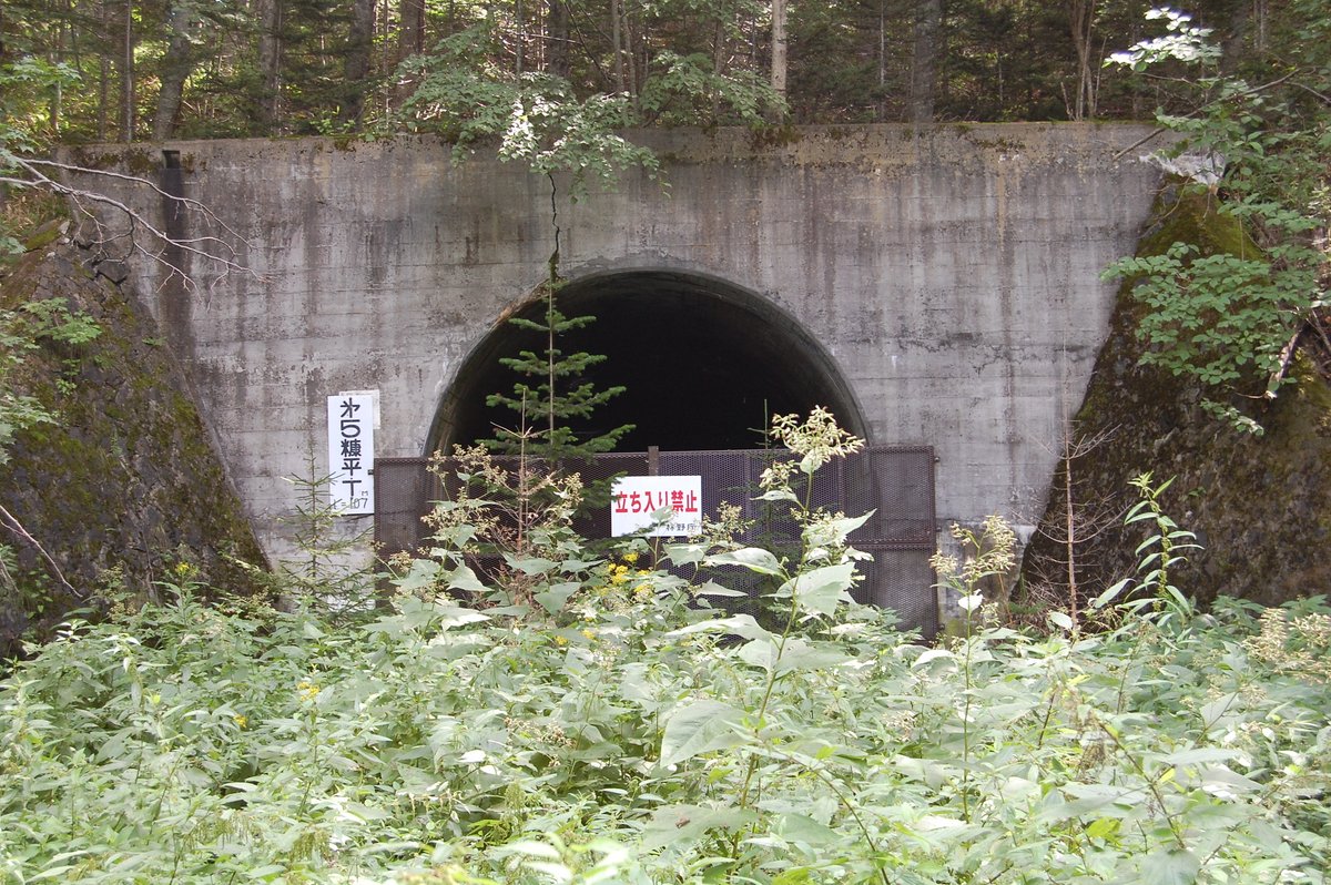
国道の糠平跨線橋の下、電力所前方には第4糠平トンネル、糠平方には第5糠平トンネルがあるが、ともにコンクリートでふさがれている。両トンネルの間には、第1糠平沢橋梁の橋台もある。


国道から遊歩道になっている旧国道へ入ると、糠平湖に沿った路盤が見え、第5糠平トンネルの糠平方も旧国道から行くことができる。


不二川橋梁も両側の橋台を残すだけになっているが、渡ったところにある第6糠平トンネルは鉄網で閉じられ、トロッコに使われている軌道自転車の車庫?になっていた。


やがて士幌線の路盤が近づき、トンネルから士幌駅跡へと軌道自転車を利用したトロッコのための線路が敷かれている。レールは太い角材で、途中から鉄レールになっている。

レールは太くて立派なものを使っているが、長さは短く、曲線もおせじにもスムースとはいえず、枕木の間隔も広いから、国鉄線路というより、森を走るトロッコにふさわしい雰囲気になっている。

4.糠平
糠平駅跡には上士幌町鉄道資料館が建てられている。

ここには現役当時の写真をはじめ、士幌線関係資料が充実している。
レール文鎮や絵葉書などの記念品もあり、アーチ橋の詳しい情報も入手できる。

2002年版なので今は変わっている可能性あり

構内には車掌車ヨ4843や踏切などが保存されている。
その横には客車用の台車TR11もあるが、上士幌駅跡の交通公園にあったオハ62の台車だろうか。


敷き直された線路では軌道自転車を前後につけたトロッコが運行され、腕木式信号機とあいまって営業当時を感じさせていた。

休日には、資料館・トロッコともに盛況だったが、トロッコは現在運行されていない。


1980年1月撮影
今回はここまでです。
おしまいまで読んでくださり、ありがとうございました。
次回は、糠平から十勝三股へ向かいます。