
Exploring the Uncharted Seafloors - Underwater 3D Scanning Robot "MURAKUMO"

Over the years, space exploration has garnered global attention, with projects like crewed lunar missions and asteroid mining becoming increasingly realistic. Asteroids, in particular, are rich in rare metals such as nickel and platinum, holding the potential to spark a new energy revolution.
Yet, there remains an "undiscovered frontier" on Earth: the ocean floor, which covers 70% of our planet’s surface. Despite being an environment too harsh for humans to access, the ocean floor is considered Earth’s final frontier, harboring vast mineral resources, undiscovered ecosystems, and invaluable historical artifacts.

Moreover, as we face pressing global challenges like climate change, environmental pollution, and resource depletion driven by population growth, the solutions may lie not only in space but also beneath the oceans. For instance, rare metals and methane hydrates are emerging as potential next-generation energy sources.
At the same time, the urgent need for ocean environmental monitoring and ecosystem conservation requires immense data collection. To address these challenges, technologies such as Remotely Operated Underwater Vehicles (ROVs) and underwater drones are indispensable.
Underwater 3D Scanning Robot "MURAKUMO"
Remotely Operated Underwater Vehicles (ROVs) are robots connected to a controller via cables, allowing underwater operations to be carried out remotely from land or aboard ships. Equipped with underwater cameras, lights, and sonar, ROVs can transmit real-time underwater footage and data, making them invaluable for deep-sea exploration, underwater equipment inspections, and object retrieval.
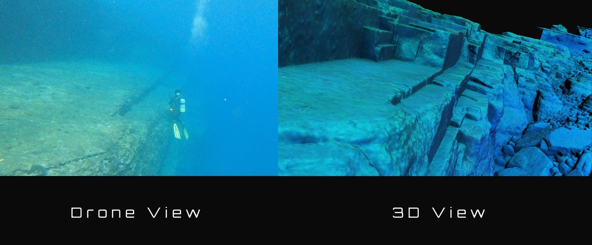
The World Scan Project (W.S.P) has developed an underwater 3D scanning robot named "Murakumo." This state-of-the-art ROV is equipped with multi-angle cameras capable of precisely scanning underwater environments. By employing photogrammetry technology to convert high-resolution image data captured by the cameras into digital 3D models and integrating these with high-resolution topographic data acquired via multibeam bathymetry, Murakumo creates highly accurate 3D models with precise positional information.

Revealing the Hidden World: Photogrammetric 3D Models
The photogrammetric 3D models used by Murakumo's data vividly recreate seafloor topography and marine environments with centimeter-level resolution, making them indispensable across various applications. For example, they enable more efficient and reliable management of fishing facilities and conservation of marine environments, tasks that traditionally relied on divers' visual inspections.
With the capability to operate at depths of up to 300 meters and create extensive 3D models spanning several kilometers to tens of kilometers, Murakumo proves invaluable for inspecting facilities built in deep waters, surveying undersea cables, investigating shipwrecks, and conducting pre-construction assessments for offshore wind farms. Unlike conventional photo and video inspections, these 3D models allow for tracking and analyzing changes over time, enabling the development of more comprehensive and effective maintenance plans for entire installations and fields.


In 2021, Murakumo’s photogrammetry technology won the "5th Infrastructure Maintenance Grand Prize - Special Award (Ministry of Agriculture, Forestry and Fisheries)." This recognition highlighted its potential to reduce costs associated with underwater drone surveys and contribute to resource management.
Survey Achievements
"Destroyer Warabi" Search Project
The "Destroyer Warabi" Search Project aimed to locate and unveil the full extent of the destroyer Warabi, which sank off the coast of Mihonoseki, Shimane Prefecture, in 1927. World Scan Project (W.S.P) collaborated with underwater archaeologist Kotaro Yamafune and the Kyushu University Research Center for Coastal Seafloor (Professor Hironobu Suga) to conduct two investigations in September 2020 and July 2021.
The investigation utilized the Murakumo, uncovering the bow section at a depth of approximately 96 meters during the first survey. In the subsequent second survey, the stern was located around 10 kilometers north-northwest of the bow at a depth of roughly 180 meters, bringing the complete structure of the Warabi to light.


The exploration at a depth of 180 meters posed extreme challenges, but thanks to the capabilities of the Murakumo system, the long-unsolved mystery of the Warabi's whereabouts was unveiled. This groundbreaking discovery garnered significant attention from the media.
Seafloor Topography Survey on Yonaguni Island
In April 2021, an underwater terrain survey was conducted in Yonaguni Town, Okinawa Prefecture. Using the Murakumo, a wide 60m × 300m area was successfully 3D scanned, marking the first-ever 3D modeling of the region's underwater terrain. This 3D scan represents the largest underwater drone-based survey in the world and has made significant contributions to the protection of tourism resources and advancements in marine environmental research.
The Murakumo's 3D scanning capabilities are unaffected by water clarity, enabling precise data collection even in low-visibility underwater environments such as deep-sea or muddy terrains. Its versatility supports various applications, including inspections of facilities in turbid waters, management of fishing grounds, and monitoring the condition of submarine cables, paving the way for new possibilities in ocean exploration.
Expanding Possibilities Through Underwater Surveys
The Murakumo broadens possibilities across various fields, including industry, environmental conservation, and scientific research.
Robotic Maintenance for Offshore Wind Farms and Submarine Cables
To promote the expansion of renewable energy, the World Scan Project (W.S.P) is actively working to support the widespread adoption of offshore wind power. With the Murakumo, maintenance inspections of offshore wind farms can be conducted in less time and at reduced costs, streamlining maintenance planning and improving operational efficiency.

Additionally, Murakumo's 3D scanning data of the seafloor plays a crucial role in submarine cable installation simulations. High-resolution models of the seafloor provide accurate environmental assessments of installation sites, reducing risks and enhancing operational efficiency during cable deployment. Post-installation, regular maintenance with the Murakumo enables rapid detection of deterioration or damage, extending the lifespan of submarine cables.

Source: Kyushu University (Research Center for Coastal Seafloor)
Marine Resource Exploration
The Murakumo excels in diverse environments, including depths of up to 300 meters, turbid waters, and areas with complex underwater topography, offering revolutionary technology for marine resource exploration. Beyond capturing extensive high-resolution imagery and 3D scan data, its photogrammetric 3D models enable detailed and three-dimensional visualization of resource distribution and geological features that traditional methods struggled to detect.
The data collected is instrumental in optimizing resource extraction while minimizing environmental impact. By utilizing photogrammetric 3D models, the planning of natural gas and rare metal extraction can be based on accurate topographical information and precise resource distribution data, enabling the creation of optimal extraction routes. This advanced technology supports the future of marine resource exploration, playing a critical role in achieving sustainable resource development and marine environmental preservation.
Seafloor 3D Scanning Service and Virtual "Sea Street®"
The photogrammetric 3D models of seafloors and shipwrecks created using Murakumo's 3D scanning data offer unparalleled accuracy, capturing details that traditional photos and videos cannot. These models hold tremendous potential as visually engaging and interactive educational tools.
For example, the seafloor 3D scanning service and virtual underwater exploration platform Sea Street®, powered by the Murakumo, combines VR (Virtual Reality) and AR (Augmented Reality) technologies to deliver an immersive experience, allowing users to explore the seafloor and shipwrecks as if they were truly there. This not only aids in the intuitive understanding of maritime technology and the history of navigation in fields such as oceanography and archaeology but also facilitates a deeper level of learning by presenting information in a three-dimensional, engaging manner that transcends the limitations of conventional images or videos.
Unlocking the Ocean’s Hidden Potential
Beneath the ocean lies untapped potential, ranging from the discovery of mineral resources and energy development to the excavation of historical artifacts. Underwater robotics technology serves as the key to unlocking these possibilities. At the forefront of this effort is the Murakumo, which leverages high-precision 3D scanning technology to uncover and preserve lost shipwrecks and historical treasures while also making significant contributions to industrial fields by reducing costs and enhancing operational safety.
Moreover, seafloor exploration plays a crucial role in environmental conservation. By monitoring marine environments that are particularly vulnerable to climate change, we can lay the foundation for a sustainable future. Utilizing the Murakumo enables the long-term documentation of seafloor topography, providing invaluable data for developing strategies to address global environmental changes.

World Scan Project (W.S.P) will continue to uncover the unknowns of the seafloor while contributing to the sustainability of Earth's future and its oceans. Stay tuned for the new horizons opened by the Murakumo and its groundbreaking discoveries.

Related Information
・Imperial Japanese Navy "Destroyer Warabi" Search Project I - Mihonoseki Incident, an unprecedented accident in naval history
・Imperial Japanese Navy "Destroyer Warabi" Search Project II - Discovery After 93 Years
WORLD SCAN PROJECT, Inc.