
Atsunai, Urahoro Town, Tokachi District, Hokkaidō (北海道十勝郡浦幌町厚内)

[Image credit : The header is from 『旅と鉄道』2023年増刊2月号「ローカル線がすべて分かる鉄道地図帳」]
This article continues from the following article, but not intended to be a railway travel report:
On 30th August 2014, I took a local train of JR Nemuro Main Line (JR根室本線) from Takikawa (滝川) to Kushiro (釧路). The train with ID 2429D was then the "longest" local train in Japan, leaving Takikawa at 09:36 and arriving at Kushiro at 18:03, so it was 8 hours train ride for 304.8 Km.
After the train left Urahoro (浦幌), it stopped at Kami-Atsunai (上厚内), which is no longer a station, and Atsunai (厚内). Soon after the train left Atsunai suddenly the Pacific Ocean came into my view. It was a sunny day in late August, and the ocean did not have any gloomy image. It was a kind of unforgettable scene, and I wanted to visit this area, particularly Atsunai.
Fortunately I had an opportunity to travel from Kushiro to Ikeda by taking local trains of JR Nemuro Main Line on 5th June 2024, 10 years after my first experience.
It was cloudy, and when I arrived at Kushiro Airport, the temperature was below 10 degrees Celsius. After visiting several stations in JR Nemuro Main Line, I took local train 2526D bound for Obihiro (帯広) from Kushiro. On the way from Ombetsu (音別) to Atsunai, I saw Shakubetsu (尺別) signaling station and Chokubetsu (直別) signaling station, both of which were stations open to passengers until 15th March 2019.
When the train arrived at Atsunai, it was not raining yet, as I left Atsunai station and started walking, it began to rain, which was annoying…the expected Pacific Ocean under blue sky in eastern Hokkaidō ended in a fleeting dream🤨

Although rain inevitably limited the scope of activities, I paid visits to Atsunai Shrine (厚内神社) and Chipuneokoppe Shrine (チプネオコッペ神社), then walked further to see the Pacific Ocean.


While the weather was so unfavorable, what made this trip dropping at Atsunai station particularly unique and unforgettable was an encounter with a person at Atsunai station. He introduced himself to me as follows:
He now lives in Kumamoto Prefecture, and is three years older than me.
After his wife passed away a few years ago, he decided to walk around Japan, and indeed he walked to this station after visiting various places in Hokkaidō.
His plan was to spend the night in the station waiting room, after having a conversation, however, we together took train 2528D bound for Memuro (芽室). I got off the train at Urahoro, while he continued his travel to Obihiro.
Just a few days ago, I confirmed that he had safely returned to Kumamoto👍
A fishing village in Tokachi Subprefecture
Atsunai is a fishing village belonging to Urahoro Town (浦幌町) located at the easternmost tip of the Tokachi (十勝) region, therefore, Atsunai Station is also the easternmost station in Tokachi Subprefecture, the center of which is Obihiro. Obihiro being known for its inland climate with hot summers and cold winters with an annual difference of 50 degrees Celsius, Atsunai is an exceptional place in Tokachi region.

https://obikan.jp/access/

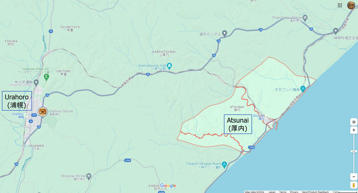

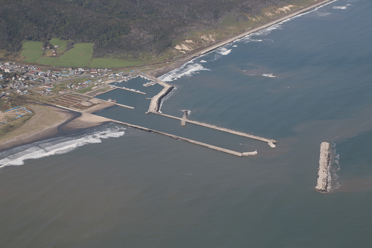
Image by Hokkaidō Association of Fisheries Infrastructure
https://hokkaido-gyokou.jp/fishing_port/urahoro/
Place names of Ainu origin in Urahoro Town
It is obvious that the place names Urahoro and Atsunai are of Ainu origin.
According to "RIWKA", Ainu Culture Information Center, Obihiro Centennial City Museum (帯広百年記念館 アイヌ民族文化情報センター「リウカ」), the origin of Urahoro & Atsunai are explained as follows:

So, Urahoro probably meant 1) where Paeonia obovata (ヤマシャクヤク) grows, 2) a foggy place or 3) lots of rigs to catch fish, and Atsunai meant a river of hooks.
Some papers are available via Historical Museum of Urahoro (浦幌町立博物館) such as "Place names of Ainu origin in Urahoro Town" 『浦幌町のアイヌ語地名』(by Hidehiko Gotō 後藤秀彦), according to which, there's a description in which a place name that suggests Tokachi (十勝) is mentioned in a book "Reize Van Maarten Gerritsz. Vries in 1643 Naar Het Noorden En Oosten Van Japan" 『日本北東航海旅行記』by Maarten Gerritszoon Vries, also referred to as de Vries, a 17th-century Dutch cartographer and explorer, the first Western European to leave an account of his visit to Ezo, Sakhalin, Kuril Islands and the Sea of Okhotsk. Briefly describing,
Aboard the Castricum as commander of the 2nd Pacific Expedition, formed to search for a legendary island off the eastern coast of Japan that was believed to be rich in gold and silver, …, the ship called at Akkeshi (厚岸) in Ezo (蝦夷 present-day Hokkaidō) on August 15, 1643.
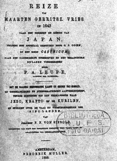
published in 1858 (via Kyōto University of Foreign Studies)
Wikipedia for Maarten Gerritszoon Vries contains two maps (one in Italian and the other in French). In both maps, Hokkaidō is not depicted as an island.
It is very interesting to find place names in "Isola di Niphon" such as
Zungar (津軽), Nanbu (南部), Yechingo (越後), Noto (能登), Surunga (駿河), Tango (丹後), Tamba (丹波), Idzumo (出雲), Aqui (隠岐), Iyo (伊予), Tosa (土佐),... for provinces
Sacata (酒田), Iendo (江戸), Ocazaqui (岡崎), Sacay (堺)… for cities
In addition, the map in French depicts Détroit de Vries (Vries Strait in English, 択捉水道 in Japanese). It gives me an opportunity to realize that it was the boarder between Russia and Japan agreed by "Treaty of Commerce and Navigation between Japan and Russia" in 1855…


Ainu ruins in Urahoro Town
Although I just briefly searched for Ainu ruins in Urahoro Town, at least 4 ruins remain in Urahoro Town, three of which are depicted in the map below:

Closing
The next day (6th June 2024), I visited Ashoro Museum of Paleontology (足寄動物化石博物館), and encountered an exhibition of Cretaceous-Paleogene boundary (K/T boundary) found at Kawaruppu, Urahoro Town (浦幌町川流布).
I'm convinced that I should visit Urahoro again next year 🙏
The following site is very helpful: