能登災害UAV写真測量業務について

だらだらと言語もさだまらず書いております。
■Timeline (てげてげ)
□1/1 Earthquake
□1/? I knew the Noto region name "Anamizu" on X.
□1/? Tasking manager launched.
I thought I didn't go to Noto because there was no agreement on the Noto.
要するに現地にはとうぶんいかないだろうと完全に油断してた。
□1/7
11:48 Calling from GEOSURF adviser. (After taking the bath)
11:54 Contact to Nihonkai aerial survey.
12:05 Call to VTOL user 1.
(Drone : https://quantum-systems.com/trinity-pro/)
12:52 Call GEOSURF, our CTO is in the office. then request charging the mobile battery.
いろいろと連絡しつつ小一時間でVTOLの手配をある程度固めつつ、eBeeXの準備他のため、会社へ。。
While going to the office.
Help via X, facebook, and DRONEBIRD.
いろいろとヘルプコメントいただきました。(ありがたやー)


I found that our car has normal tires.
I searched Big luggage space car equipped with snow tires.
結果、積載力としては落ちるし、4WDがほしかったが時間と選択肢がない。

After the mission
14:00 Arrive at the office.
Purchased snack.
16:00 Departure to Ageo city
18:15 Arrived Nipponrentacar - Ageo station shop. But Hiace has not prepared yet.
18:30 DIY shop(Temp. tilet, size AA battery(単三電池) for transceiver, no sleeves outer, ), but there is no 2L water bottle.
18:50 My house, get a sleeping bag, non-drinking water stock & toilet paper.
19:15 Back to rentacar shop
結局自宅付近(駐車場があるから)でスタットレスのキャラバンを借りて荷物を載せ変えてから現地に向かうことに。
??:?? Get certification for BLOS, high altitude, above the third person, in the airport's limited flight area.
(Like DRONEBIRD, no serial number)
ほぼDRONEBIRDと同じ運用が可能になった。元請さんが事前にとっていたドローンに追加する形で許可がでた。直接はコンタクトとってないが航空局もなかなか大変そうだなぁ。


□1/8
0:30
I checked the map around the target area. Wow, Jesus Christ! Too close to the Airport.
もう向かってるけど、まじやべぇところでしたw

4:30
Arrived at road station TAKAMATSU
5:00
I met the 3 NihonkaiAS members.
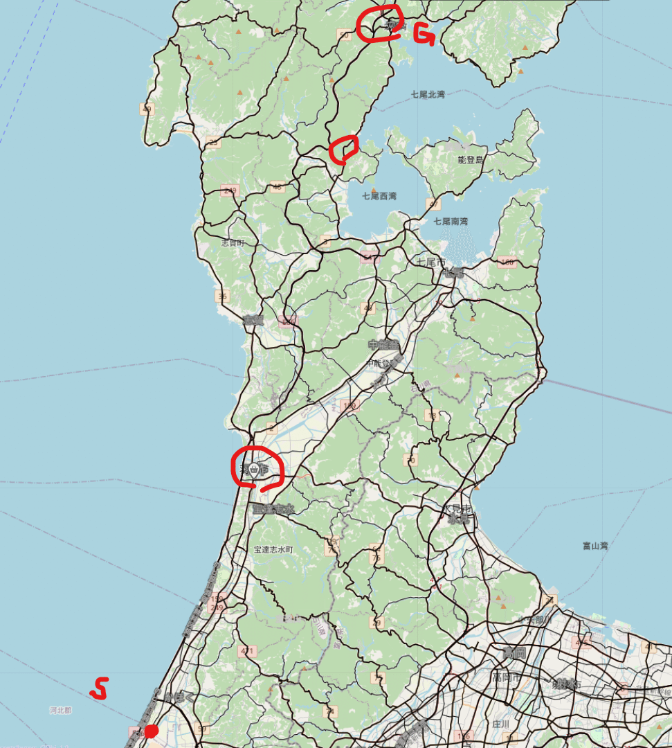
Then go to the Anamizu IC.
No announced waypoints
最初に道案内は欲しかったな。。
waypoint 1. seven eleven(last convenient shop)
waypoint 2.
Crazy weather condition.
Cold battery.
Only 1 flight.
Click trigger button more than 700 times.
□1/9
Crazy weather conditions.
Cold battery.
Back to Kanazawa(For Meeting)
飛ばせなかったもんで早じまい。

□1/10
Pre-site check with WING(Drone laser).
Mapillary on heavy traffic jams.
There was a line to use the restroom.(Waypoint2)
(Gathered emergency rescue cars from other pref.)
https://www.mapillary.com/app/?pKey=284883184583882
15:00 Arrived
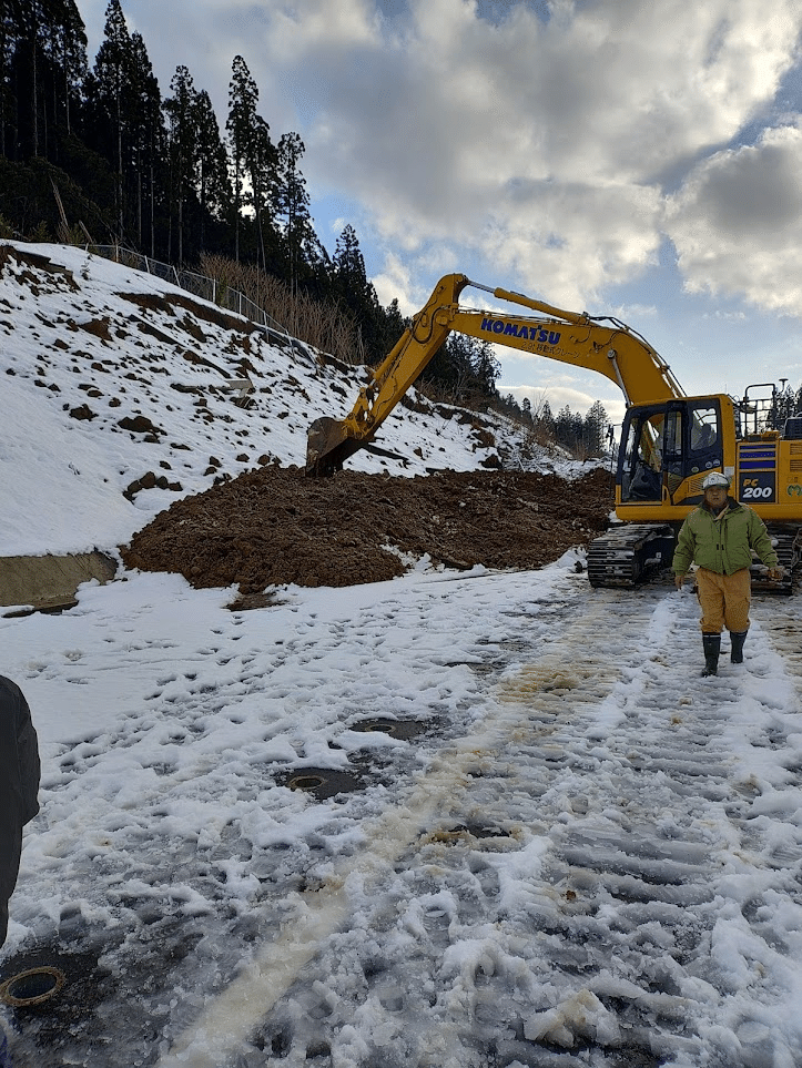
Obayashi starts repairing near the Mii IC
Softball ground is good for VTOL to take off & landing.
(Pre-road repair has finished! - Failed camera setting of Gopro)
Heavy traffic jams.
23:40 joyful
□1/11
Set local Kinematic base(Mention later)

Get breaking time during self-defense force helicopter.
(13:00 - 14:00)

Mapillary after the flight. (Not updated now)
□1/12
Material donation
https://maps.app.goo.gl/qzDwDPfS61Ddz5pSA
Go D-Academy Ishikawa
Go すしべん, Ageo, rentacar shop(20:00),
supermarket, & sleep.
■Car navigation
(10年以上前の知識)通常の道路規制では工事受注業者が専用のアカウント与えられて、オンラインで規制開始・終了を登録して、衛星経由でカーナビなどに反映される。(よく規制解除忘れて怒られた。じゃあお前がけせよって思ってた。)
自衛隊・警察などがほかのルートを持ってるかわからないが、道路補修作業での片交や通行止めの情報は追加・更新されない可能性が高い。
実際ナビの情報はあっていなかった。
案内看板は段ボールとかもあるし、ふつうに地べたにおいてあるし、暗いとみにくい。軌跡表示(白プロット)とか最終目的地の方向(ピンクの線)とかは有効だと思うからカーナビも使いこなすべし。

ようは、あんまりあてにならない。現地人が死を感じるくらいw
移動だけで死ねる>< https://t.co/U9Yp9GalYi
— とっしい@じぞまえ (@jizomae) January 10, 2024
ナビにない一方通行規制があるので、1か所間違えただけで、
輪島に向かう東北電力の車両10台くらいがこんなとこきちゃう。
おそらく1時間くらいのロスがでたはず。。
■Road condition
No As mixed pavement material slope.
Short slope. From a higher direction, I can't find the slope.


■Drone(VTOL)
Use a rod to extend the radio range.

■RTK/VRS/PPK
VTOL (PPK)
Phantom4RTK(PPK)
Drone laser(VRS? >> PPK)
□VRSは最高だけど、PPKが最強。
書いた後でこんなん見つけた。
https://psgsv2.gsi.go.jp/koukyou/public/jishin/noto_R6/notojishin_R6.html
■SfM
Image data: More than 2600, about 50Gb
Camera
https://enterprise.dji.com/jp/phantom-4-rtk/specs
Orthomosaic
: 19Gb
CONFIDENTIAL!! (Password)
Please check the data of 2024/1/18
Written by
DRONEBIRD
Semi squadder Mirai Koujimaru
