
Lake Miyagase, Tsukui, Shiroyama training route (with map)

For cyclists in the Tokyo area, it's a good idea to start at Lawson or the cycle cafe "CROSS COFFEE" near Yanokuchi Station in Inagi City, Tokyo, then have lunch at the steak restaurant "STUMP" near Miyagase Dam, or go to Lake Tsukui. A regular stop is a cafe called ``ZEBRA Coffee.''
東京近郊のサイクリストにとって、東京都稲城市の矢野口駅近くのローソンかサイクルカフェ「CROSS COFFEE」に集合して出発し、宮ヶ瀬ダム近くにあるステーキレストラン「STUMP」でランチを食べたり、津久井湖近くにあるカフェ「ZEBRA Coffee」に寄ったりするのは定番のコースだ。
This time, we rode on a peaceful road with as few cars as possible along the way, and did many ups and downs. We have set up a course for when you want to ride as hard as you can on from the city center.
There are cafes, ice cream shops, and many convenience stores along the way, so it's a course that you can flexibly ride by stopping at or not depending on your physical condition and time.
今回は、途中からなるべく車通りの少ないのどかな風景の道を走りながら、アップダウンを多めに。都心から自走できる範囲でしっかり乗りたいというときのためのコースを設定。
途中にカフェやアイスクリーム屋さんもあるし、コンビニもたくさんあるから、体調と時間に合わせて、寄ったり、寄らなかったり、臨機応変に走れるコースだ。
It was a still hot day in early September when we rode with my friends. We left Yanokuchi Lawson at 7:30.
Passed through the “Onekan Line'', and went straight along a road with a lot of traffic until we reached the area around Hashimoto Station. After crossing the Sagami River at Kokura Bridge, choosed a peaceful road with lots of greenery.
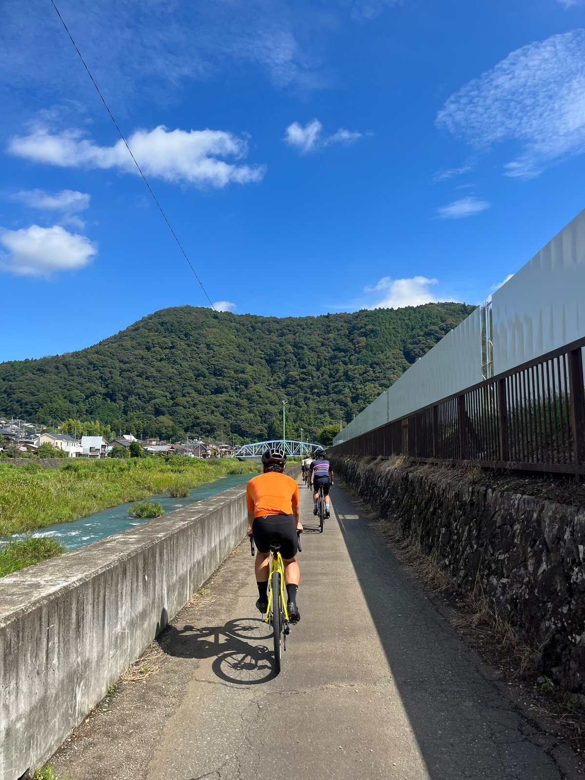
仲間と一緒に5人で走ったのは、9月はじめのまだまだ暑い日。7時半に矢野口ローソンを出発した。
南多摩尾根幹線、通称“尾根幹”を抜け、橋本駅の周辺まではやや車通りが多い道をまっすぐに行く。小倉橋で相模川を渡ったあとは、緑の多い、のどかな道を選ぶ。
After climbing up Mimase Pass and descending down the pleasant shaded path, we went up again... There were also some steep slope sections. We arrived at "STUMP" after many ups and downs, taking a break at a convenience store along the way, but it was over an hour before it opened at 11:30, so we decided to skip it this time.
We had a panini and coffee lunch at the cafe “Cafe & Cozy Cabin Garachico'' at 48 km point on the route.
三増峠を上って下り、気持ちのよい木陰の道を下ったあとは、また上って……。激坂区間も少々。途中コンビニ休憩もはさみながら、アップダウンを繰り返して「STUMP」に到着するも、オープン時間の11時30分までには1時間以上あるため今回はスルー。
その先にあるカフェ、ルート上48km地点の「Cafe&Cozy Cabin Garachico」でパニーニとコーヒーのランチをいただいた。
After lunch, headed towards Lake Tsukui. Crossed the bridge of Lake Tsukui and went up and down while looking at the lake. We took a break at Megu Gelate, a gelato shop in Tsukui Lake Shiroyama Park, and cooled down.
ランチ後は、津久井湖方面へ。津久井湖の橋を渡り、湖をながめながらアップダウン。津久井湖城山公園のジェラート屋さん「Megu Gelate」で休憩し、暑く熱った体を冷ます。
The last big climb was the road to Lake Shiroyama. Although it is located on a road with a lot of shade from trees, it is not at a high altitude, so it gets hot in the summer. We slowly climed at our own pace.
We took a break at the Shiroyama Observation Deck at the top before descending. The route was to walk back to the main ridge, avoiding main roads as much as possible, but it was hot that day and We were feeling exhausted. We took a shortcut and went straight back down Machida Kaido.
最後の大きな上りは、城山湖への道だ。木陰の多い道ではあるものの、標高が高いわけではないので夏場は暑く、こたえる。それぞれのペースで、淡々と上っていく。
頂上の城山展望台で休憩してから下ったあと、ルートではそこから尾根幹まで、なるべく大通りを避けてクネクネと戻るのだが、この日は暑くてバテ気味に。ショートカットして町田街道をまっすぐ戻った。

The landmark is a banner with a bicycle pictogram on it.
小倉橋は東京2020オリンピックの自転車ロードレースコース。
自転車ピクトグラムがデザインされた横断幕が目印だ。
There are quite a few ups and downs, and there are some very steep sections.
小倉橋を過ぎたあとは、できるだけ車通りの少ないのどかな道を。
都心から少し離れるだけで、こんな景色に出会えるのだとうれしくなる。
アップダウンはやや多めで、激坂区間も。

a tributary of the Sagami River, just opened in August 2023.
The owner is a triathlete, and there is plenty of space to park your bike on the premises,
as well as bike racks, and you can relax on the benches outside where the breeze from the river flows through. The cafe's menu includes coffee, panini, and smoothies.
The cafe's opening hours on weekends are 8:00 a.m. to 3:00 p.m.
(please note that the hours vary depending on the day of the week).
相模川の支流、串川のほとりにある「Cafe & Cozy Cabin Garachico」は
2023年8月にオープンしたばかり。
オーナーはトライアスリートで、バイクラックはもちろん、敷地内に自転車をとめられるスペースが
豊富にあり、川からの風が通り抜ける外のベンチでくつろぐのもいい。
カフェのメニューはコーヒー、パニーニ、スムージーなど。
週末のカフェ営業時間は8時〜15時(曜日によって違うので注意)。
Cafe & Cozy Cabin Garachico

There is a lot of greenery and it feels good.
津久井湖の周りはほどよいアップダウン。緑が多く気持ちが良い。

Open from 10:30 a.m. to 4:30 p.m. on Wednesdays, Saturdays, and Sundays (until sold out).
Get off your bike and walk around the park.
津久井湖城山公園“水の苑地”にあるジェラート屋さん「Megu Gelate」は、
神奈川県相模原市の食材を使ったジェラートが大人気。
水、土、日の10時30分〜16時30分ごろまで営業(売り切れ次第終了)。
公園内は自転車を降りて押し歩きを。
「Megu Gelate」

The road on the way back from the top of the route is a little rough, so be careful.
最後の長い上りは城山湖への道。城山湖は静かな人造湖で、展望台に着いたらちょっとひと息。
ルート上帰りの下りはやや道が荒れているので注意。
【ルート】
Distance: 102km
Elevation gained: approx. 1800m
Course: up and down
距離:102km
獲得標高:約1800m
コース:アップダウン

・This route is easy to take a shortcut, but if you are going to ride the entire route, be careful not to take it too leisurely during lunch or coffee time. There are many convenience stores, cafes, and lunch spots along the way, so take breaks as needed.
・ショートカットしやすいルートだが、全ルートを走るならランチやコーヒータイムでのんびりしすぎに注意。途中コンビニやカフェ、ランチスポットも多いので、適宜休憩を。